


511: The Award-Winning Source for Bay Area Transit and Travel Information
511: The Award-Winning Source for Bay Area Transit and Travel Information


As is to be expected from the creative minds in the region, the Bay Area has turned out an award-winning 511 transit information system. A product of the California Metropolitan Transportation Commission in partnership with the California Highway Patrol and state Department of Transportation, 511 folds together data from the region's two-dozen-plus transit agencies, forging an amazing utility in the process. Supported by a mix of federal, state, and local funding, the 511 program delivers its information either over the phone by dialing 5-1-1, or on the web at 511.org. All services, from a simple traffic check to help setting up an employee telework program, are free of charge.
On 511.org, a uniform interface allows users to view transit schedules and plan trips, get current traffic conditions and view active webcams, find a carpool, or perform a host of other handy functions. The transit site's extensive scope and dynamic features were recognized recently with its inclusion in the 2009 list of top 10 exemplary government websites that "embrace the Web's full potential," as compiled by the publication Government Computer News.
The concept for the system took shape 10 years ago, when the U.S. Department of Transportation petitioned the Federal Communications Commission (FCC) to designate a nationwide three-digit telephone number for traveler information. A year later, in the summer of 2000, 511 became the universal traffic information telephone number, with implementation left up to the various state and local agencies and telecommunications carriers across the country.
In California, state and municipal entities were quick to get behind this initiative, and today the Bay Area's program is acknowledged as "the most innovative in the country," according to Carol Kuester, Principal Program Coordinator, Traveler Information and 511, with the Metropolitan Transportation Commission (MTC).
The vast amount of integrated information available on the site is what earns it such high marks. In many parts of the country, 511 simply presents information on traffic on the local interstate, Keuster points out. The Bay Area's system is much more comprehensive, covering multiple transportation modes. "Our system reflects the full scope of options in the region-transit, bike, ridesharing, etc.- and we're proud of it," she states.
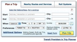
The site's home page offers a multiplicity of choices. For example, the Public Transit Trip Planner is a phenomenal tool to plot out either a daily commute or an adventurous jaunt to a wide variety of leisure destinations, from Stinson Beach to the Vallejo Ferry Terminal. This utility can now be accessed directly from the Hacienda web site at: www.hacienda.org/forms/forms_order_tripplanner.html or by selecting "Plan Your Commute" on any page where this button appears.
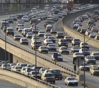
Drivers can also check out current traffic conditions and even view a live shot of the road from the growing network of video cameras, to figure out the smoothest route to their destination. Or they can use the MY 511 service to receive text or email alerts about congestion along a predetermined route.
These are just some of the highlights. Since its launch in 2002, 511.org has seen a steady succession of upgrades, largely in response to user feedback and advances in dissemination technology. Especially with the regular addition of new features, the full extent of its utility is "hard to capture in a sound bite," Keuster observes, recommending that people take some time to explore the site. "People need to experiment and find the tools and features that work for them." She also encourages those who might have tried the system in the past to take it for a fresh test drive.
There is no doubt about how Bay Area travelers benefit from the reliable source of accurate information. "We have quantitative research studies showing that if people regularly call 511, they will see a time savings," Keuster remarks, adding, "our traffic data is widely disseminated, and it the best there is. The more people who have the information, the better their decision-making will be. If there is a big incident, the last thing you want is more people driving into it."
In fact, 511 has even become an emergency response tool, even though it was not envisioned as such. As an example, Keuster cites the 2007 MacArthur Maze "meltdown," when the freeway ramp collapsed after an accident. The site immediately posted information about the incident and how traffic was being diverted. Graphical representations of the closure and detours gave drivers a level of comfort as they were funneled to alternate routes during the subsequent reconstruction.
An upcoming challenge is the Bay Bridge shutdown over Labor Day weekend, part of the Seismic Retrofit Project. The closure will begin at 8:00 pm on Thursday, September 3, with the bridge reopening by 5:00 am on Tuesday, September 8. Caltrans is coordinating with Bay Area public transit agencies to plan scheduling and route changes, and updates on transit options will be posted on 511.org as they become available.
Last year's experience with the shutdown makes things a little easier this time around, Keuster says. Traffic during the 2008 closure declined, and "it was heartening to see that the public really got the message, accepting our advice to stay home or take public transit. Working together, we have been able to avoid serious congestion."
The next step forward for 511.org is a presence in the social media arena. Keuster expects 511 to be on Facebook and Twitter this month. There is also an effort afoot to optimize web tools like the traffic map so they can be used on handheld devices. She also hopes developers will be inspired to create an iPhone application featuring the site's data feed.
Below are highlights of the latest 511 upgrades.
Transit Information
From Gilroy to Petaluma and Pacifica to Livermore, the Bay Area has more than 60 public transportation offerings. You can get information on the various providers, schedules, fares, and service announcements by selecting the Transit tab on 511.org.
The Trip Planner in this section has been described as "awesome." With answers to a few questions about where and when you are traveling, this tool will provide you with a detailed itinerary and calculate the total trip cost and travel time.
The Regional Information tab features the Popular Destinations tool, which allows a search by city or nine destination categories, like museums, parks and gardens, and sport/event venues. A link to the Trip Planner provides the itinerary for that specific trip.
Also on the Transit website are links to schedules, routes, maps, and fares for each transit agency, along with disabled and senior services information.
TransLink
The big news about TransLink, the reloadable smart card for paying transit fares, is that as of early August it is now accepted on BART - in addition to AC Transit, Dumbarton Express, and Golden Gate Transit and Ferry, where it has enjoyed growing use over the past few years.
BART riders can now dispense with paper tickets and no longer need to worry about having enough cash on hand to cover the fares, making the daily commute easy, convenient, and secure, Keuster points out.
The credit card-sized TransLink keeps track of its value and automatically deducts the correct fare (including discounts and transfers) for every transit trip. You can buy a card or add value online, on the phone, at dozens of retail locations, at transit agency ticket offices, or at transit stations.
MY 511
MY 511 is a free, personalized service that provides information on customized travel routes over the phone or online. Users can set up a list of saved trips and later access up-to-the-minute driving times for any of them by dialing 5-1-1 and speaking the trip name (e.g. "Home to Work") that was entered during the registration process. The voice network reports traffic slowdowns, complete with exact time, location, and current vehicle speeds, along routes the user specifies.
The MY 511 service can also send out e-mail and text message alerts about current conditions associated with driving and transit departure times. Users can configure the time of day, day of week, and alert type they wish to receive. A typical alert lists the trip name, the estimated travel times when the alert was sent, and incident information associated with each trip. Users can also request severity alerts when the trip's current driving time exceeds the typical driving time by 25 percent or more.
Online, the Traffic and Driving Times Map presents instant information on all freeways in the nine-county Bay Area region. Clicking a spot on the map drills down into the specific details, including construction updates, and in some areas, real-time streaming video of the selected freeway. The Predict-a-Trip allows users to query travel times for certain days of the week and hours of the day via different routes.
Rideshare
511 Rideshare offers a host of services and incentives for commuters interested in leaving their cars at home, even for just one day a week. Rideshare perks range from the ability to use carpool lanes to free bridge tolls, preferential parking, and commuter tax benefits - not to mention reduced greenhouse gas emissions and other pollutants.
The RideMatch Service helps individuals join or start a carpool or vanpool according to their specific needs, from time of day to exact destination. Special consultants are available to help applicants meet all criteria for a vanpool, including feasibility advice, assistance with van leasing, recruiting back-up drivers and passengers, and medical exam reimbursements. Also available on the Rideshare tab (or at Rideshare.511.org) is information about the Guaranteed Ride Home program, designed to help employers promote ridesharing at the workplace.
Bicycling
The Bicycling page on the 511 website is an invaluable resource for commuters and recreational cyclists alike. Here are found route maps, information on taking bikes on public transit and across Bay Area toll bridges, the location of lockers and racks, pointers on commuting and riding safely in traffic, advice on selecting a bike, and even links to cycling organizations.
A Bike Buddy Ridematch feature connects bikers for commuting or weekend rides and links experienced cyclists to newcomers who need to learn bike routes. The BikeMapper online tool works like the Transit Trip Planner, providing all possible bike routes within a user-specified area.
Additional Information and Services
The 511 umbrella offers more information and additional services either by phone or online. Find out about FasTrak, the automated toll payment system that allows drivers to cruise through Bay Area toll plazas at up to 25 miles per hour. Get information and announcements about Spare-the-Air days, surveys, and participation in transit research.
The web site also furnishes links to many other resources including airports, car sharing programs, local travel information services, 511 programs outside the Bay Area, and Bay Area tourist information such as links to local convention and visitors bureaus and Chambers of Commerce.
Also in this issue...
- Hacienda Surgery Center Ramps Up Quickly
- Attorneys and Staff at Hoge, Fenton, Jones & Appel Enjoy New Hacienda Home
- Business Bits
- Executive Profile: Neisha Becton, Becton Healthcare Resources
- GlassHouse Technologies' Hacienda Office is Customer Support Services Hub
- NCS Exchange Professionals See Investors Moving Back into Real Estate
- 511: The Award-Winning Source for Bay Area Transit and Travel Information
- October Pillars of the Tri-Valley Event Promotes Board Opportunities for Nonprofits
- Heart Walk Emphasizes Prevention through Fitness
- Pleasanton Military Families Provide Comfort to Soldiers and Folks Back Home
- Hacienda Index
- Calendar